Geography for your homeschool
Your child uses maps and evidence to explain why people, resources, and environments are distributed the way they are.
A lesson built around your child
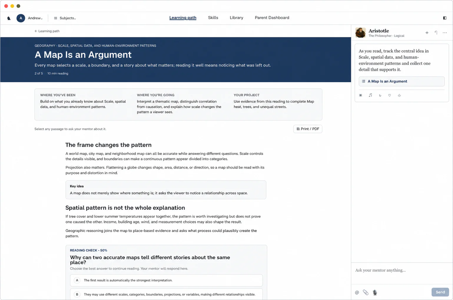
Every map selects a scale, a boundary, and a story about what matters; reading it well means noticing what was left out.
- Lesson
- A Map Is an Argument
- Goal
- Interpret a thematic map, distinguish correlation from causation, and explain how scale changes the pattern a viewer sees.
How a lesson works
A 10-minute reading
This example lesson comes from the unit on scale, spatial data, and human-environment patterns. It moves from “The frame changes the pattern” to “Spatial pattern is not the whole explanation” and builds to one idea: a map does not merely show where something is; it asks the viewer to notice a relationship across space.
Help inside the reading
If a map seems to show a pattern, our Always-On Mentor can help your child check its scale, source, and what might explain it. Your child can also highlight any line of “A Map Is an Argument” to ask about it or ask for a visual, and the mentor offers help on its own when they seem stuck.
A check halfway through
Your child answers “Why can two accurate maps tell different stories about the same place?” before reading on, and the Reading Check at the end asks new questions.
A project your child hands in
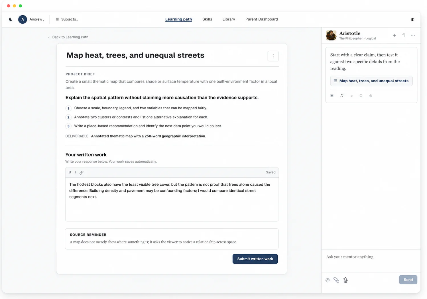
Create a small thematic map that compares shade or surface temperature with one built-environment factor in a local area.
- Task
- Explain the spatial pattern without claiming more causation than the evidence supports
- Hand in
- Annotated thematic map with a 250-word geographic interpretation
Your parent dashboard
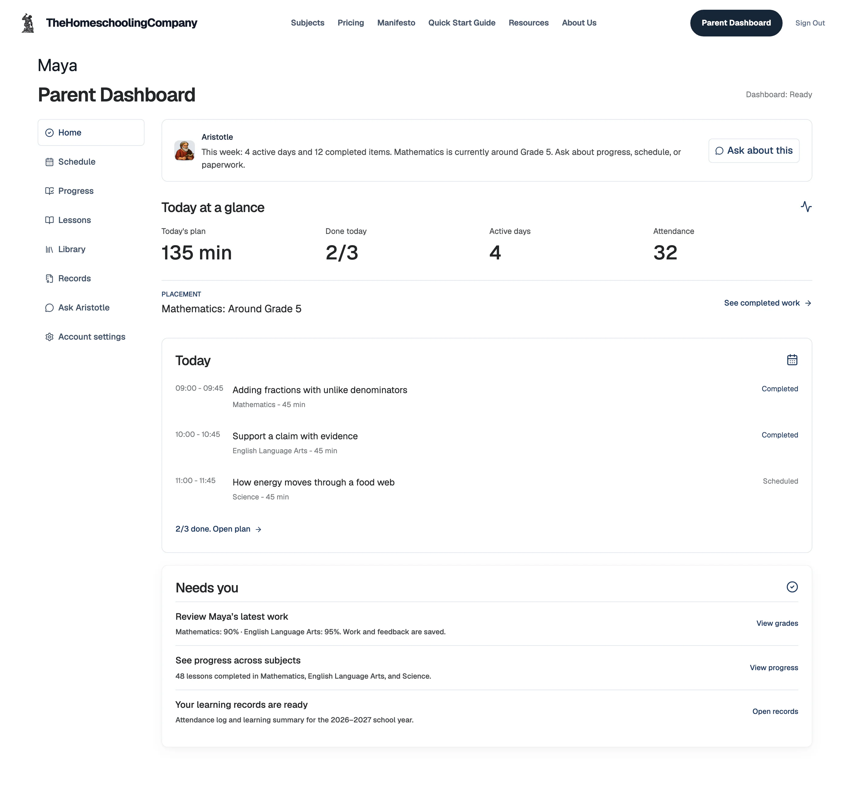
- Today
- Each subject's lesson, and whether it's done
- Grades
- Every submission graded instantly, with written feedback, so you never grade
- Records
- Attendance log and learning summary, ready to export
Units and skills
The course teaches geography as reasoning about place, across physical and human systems, maps, regions, the environment, migration, cities, and trade. Geography is one skill tree for every grade with 12 units, from location, scale, and spatial thinking to regional analysis capstone, and your child's grade sets how deep each unit goes.
Geography12 units · 60 skills
Location, scale, and spatial thinking5 skills
- Define the vocabulary, boundaries, and common misconceptions of Location, scale, and spatial thinking
- Explain the main actors, mechanisms, sequence, and constraints in Location, scale, and spatial thinking
- Interpret evidence, data, cases, or examples connected to Location, scale, and spatial thinking
- Apply Location, scale, and spatial thinking to a realistic spatial or regional problem
- Create a map-backed regional brief that justifies decisions about Location, scale, and spatial thinking
Maps, projections, and geospatial data5 skills
- Define the vocabulary, boundaries, and common misconceptions of Maps, projections, and geospatial data
- Explain the main actors, mechanisms, sequence, and constraints in Maps, projections, and geospatial data
- Interpret evidence, data, cases, or examples connected to Maps, projections, and geospatial data
- Apply Maps, projections, and geospatial data to a realistic spatial or regional problem
- Create a map-backed regional brief that justifies decisions about Maps, projections, and geospatial data
Physical systems and landforms5 skills
- Define the vocabulary, boundaries, and common misconceptions of Physical systems and landforms
- Explain the main actors, mechanisms, sequence, and constraints in Physical systems and landforms
- Interpret evidence, data, cases, or examples connected to Physical systems and landforms
- Apply Physical systems and landforms to a realistic spatial or regional problem
- Create a map-backed regional brief that justifies decisions about Physical systems and landforms
Climate, biomes, and human adaptation5 skills
- Define the vocabulary, boundaries, and common misconceptions of Climate, biomes, and human adaptation
- Explain the main actors, mechanisms, sequence, and constraints in Climate, biomes, and human adaptation
- Interpret evidence, data, cases, or examples connected to Climate, biomes, and human adaptation
- Apply Climate, biomes, and human adaptation to a realistic spatial or regional problem
- Create a map-backed regional brief that justifies decisions about Climate, biomes, and human adaptation
Population patterns and migration5 skills
- Define the vocabulary, boundaries, and common misconceptions of Population patterns and migration
- Explain the main actors, mechanisms, sequence, and constraints in Population patterns and migration
- Interpret evidence, data, cases, or examples connected to Population patterns and migration
- Apply Population patterns and migration to a realistic spatial or regional problem
- Create a map-backed regional brief that justifies decisions about Population patterns and migration
Culture, language, and regional identity5 skills
- Define the vocabulary, boundaries, and common misconceptions of Culture, language, and regional identity
- Explain the main actors, mechanisms, sequence, and constraints in Culture, language, and regional identity
- Interpret evidence, data, cases, or examples connected to Culture, language, and regional identity
- Apply Culture, language, and regional identity to a realistic spatial or regional problem
- Create a map-backed regional brief that justifies decisions about Culture, language, and regional identity
Cities, settlement, and land use5 skills
- Define the vocabulary, boundaries, and common misconceptions of Cities, settlement, and land use
- Explain the main actors, mechanisms, sequence, and constraints in Cities, settlement, and land use
- Interpret evidence, data, cases, or examples connected to Cities, settlement, and land use
- Apply Cities, settlement, and land use to a realistic spatial or regional problem
- Create a map-backed regional brief that justifies decisions about Cities, settlement, and land use
Economic geography and trade networks5 skills
- Define the vocabulary, boundaries, and common misconceptions of Economic geography and trade networks
- Explain the main actors, mechanisms, sequence, and constraints in Economic geography and trade networks
- Interpret evidence, data, cases, or examples connected to Economic geography and trade networks
- Apply Economic geography and trade networks to a realistic spatial or regional problem
- Create a map-backed regional brief that justifies decisions about Economic geography and trade networks
Political geography and borders5 skills
- Define the vocabulary, boundaries, and common misconceptions of Political geography and borders
- Explain the main actors, mechanisms, sequence, and constraints in Political geography and borders
- Interpret evidence, data, cases, or examples connected to Political geography and borders
- Apply Political geography and borders to a realistic spatial or regional problem
- Create a map-backed regional brief that justifies decisions about Political geography and borders
Resources, hazards, and environmental change5 skills
- Define the vocabulary, boundaries, and common misconceptions of Resources, hazards, and environmental change
- Explain the main actors, mechanisms, sequence, and constraints in Resources, hazards, and environmental change
- Interpret evidence, data, cases, or examples connected to Resources, hazards, and environmental change
- Apply Resources, hazards, and environmental change to a realistic spatial or regional problem
- Create a map-backed regional brief that justifies decisions about Resources, hazards, and environmental change
GIS inquiry and spatial evidence5 skills
- Define the vocabulary, boundaries, and common misconceptions of GIS inquiry and spatial evidence
- Explain the main actors, mechanisms, sequence, and constraints in GIS inquiry and spatial evidence
- Interpret evidence, data, cases, or examples connected to GIS inquiry and spatial evidence
- Apply GIS inquiry and spatial evidence to a realistic spatial or regional problem
- Create a map-backed regional brief that justifies decisions about GIS inquiry and spatial evidence
Regional analysis capstone5 skills
- Define the vocabulary, boundaries, and common misconceptions of Regional analysis capstone
- Explain the main actors, mechanisms, sequence, and constraints in Regional analysis capstone
- Interpret evidence, data, cases, or examples connected to Regional analysis capstone
- Apply Regional analysis capstone to a realistic spatial or regional problem
- Create a map-backed regional brief that justifies decisions about Regional analysis capstone
Questions parents ask
Which grades can use this Geography curriculum?
- One Geography skill tree serves grades 3 to 12, with course pages for 6th grade and high school. Placement checks your child's current skills, so the first lesson can sit before or after their grade.
What should my child know before starting?
- Starting skills include basic map familiarity, interest in the world, and willingness to look things up. If placement finds a gap, the course starts with those skills.
How much of the teaching do I do?
- None of it. The course explains each new idea and checks how your child uses it, while the mentor answers questions as they work. Every submission is graded as soon as it comes in, so you never grade it yourself.
Can I use the record for high-school planning?
- Yes. The subject record holds every graded assignment with its written feedback, ready to export. We generate a transcript from the course records, ready for you to sign.
Geography, taught around your child
A geographic lens your learner can use on any place or problem.
$49/month after the trial.